| News |
| Events | |
| Int’l Cooperation News | |
| Upcoming Events |
 |
| Location: Home > News > Events |
| Scientists found water storage Increased in North America and Scandinavia from GRACE gravity data | TEXT SIZE:A A A |
Natural and anthropogenic stresses such as climate change, drought and deluge, increasing water use, land use and agricultural practices affect surface and groundwater resources globally. A small change in the hydrological cycle may have a significant socio-economic impact, which, for example, has recently been observed in the form of groundwater depletion in northwest India probably leading to reduction of agricultural output and shortages of potable water. It is thus of importance to determine the spatial and temporal variability in continental water storage.
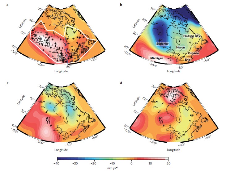
The Gravity Recovery and Climate Experiment (GRACE) satellite mission has proved to be an invaluable tool in monitoring such hydrological changes with global coverage and sufficient spatial and temporal resolution. Gravity data from GRACE have revealed trends in present-day continental water storage in many parts of the world. In North America and northern Europe, it has been difficult to provide reliable estimates because of the strong background signals of glacial isostatic adjustment. Attempts to separate the hydrologic signal from the background with numerical models are affected by uncertainties in our understanding of the precise glacial history and mantle viscosity. Wang Hansheng, a leading scientist in the research project, used a combination of GRACE data and measurements from the global positioning system to separate the hydrological signals without any model assumptions. According to their estimates, water storage in central North America increased by 43.0±5.0 Gt yr−1 over the past decade (Fig1). They attribute this increase to a recovery in terrestrial water storage after the extreme Canadian Prairies drought between 1999 and 2005. They find a smaller rise in water storage in southern Scandinavia, by 2.3±0.8 Gt yr−1. In both North America and Scandinavia, their computed increases in water storage are consistent with long-term observations of terrestrial water level. They suggest that the detected mass gains in terrestrial water storage need to be taken into account in studies on global sea-level rise.
Figure1. Hydrology trend rates in North America in equivalent water thickness. a, Using CSR GRACE data and GPS data from ref. 29 in the separation approach. b, Using CSR GRACE data but with ICE-5G(VM2) (ref. 16) model predictions for correction. c,WGHM (ref. 13). d, GLDAS/NOAH (ref. 12) hydrology model. The label A marks the trend peak in the Canadian Prairies and B marks that in the Great Lakes for investigation in Fig. 3. Crosses denote GPS sites. A white line surrounds the investigation area, which depends on a dense GPS network. The area west of the dashed blue line is used for mass change calculation. See Supplementary Fig. S12 for uncertainties.
They proposed a separation approach based on a modified extension of the method, which allows the self determination of the hydrological contribution from GRACE and GPS data. Hence, the separation is not GIA model dependent. The results showed that their method can be used to improve the hydrology models, especially the long-term trends in selected areas. The work entitled “Increased water storage in North America and Scandinavia from GRACE gravity data” has been published in Nature of Geosciences. |

