According to the China Earthquake Networks Center, a massive earthquake with a magnitude of 8.1 struck 80 kilometres east of Pokhara in Nepal On April 25, 2015 at 2:11 p.m. (Beijing Time), with a depth of 20 kilometers. It caused serious casualties, cultural heritage damage and economic loss, and secondary disasters such as avalanches, landslides, and barrier lakes were triggered by this earthquake.
IGG used radar data provided by the European Space Agency(ESA) Sentinel-1A Satellite to get the co-seismic deformation field in LOS direction around Kathmandu region. This large extension, high resolution deformation field data can provide important constraint for estimating slippage.
Satellite radar data for surface deformation monitoring are gaining increasing attention, and not only within the oil and gas community. They provide a powerful tool for re-motely measuring extremely small surface displacements over large areas and long periods of time, without requiring the installation of in-situ equipment.
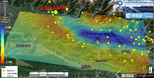
InSAR co-seismic deformation of Kathmandu region