According to the China Earthquake Networks Center, a earthquake with a magnitude of 6.7 struck Taiwan's Kaohsiung city On February 6, 2016 at 3:57 a.m. (Beijing Time), with a depth of 23 kilometers. It caused serious casualties and economic loss.
IGG used radar data provided by the European Space Agency(ESA) Sentinel-1A Satellite to get the coseismic deformation field in LOS(Line-Of-Sight) direction around Kaohsiung city. The range of surface influence of this earthquake is about 30 km×30 km, the largest coseismic deformation is about 0.2m(LOS).
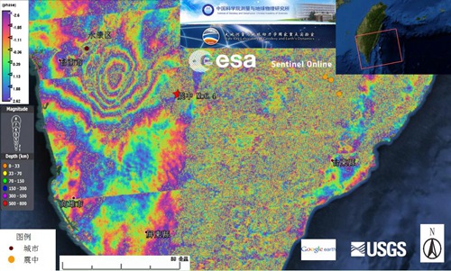
Sentinel-1A coseismic interferogram of Tainan earthquake