Associate Prof. Shen Qiang from Institute of Geodesy and Geophysics, Chinese Academy of Sciences(IGG,CAS) completed the highest-resolution Antarctic ice velocity maps so far in 2014 and 2015 collaborated with The Ohio State University’s School of Earth Sciences under the support of the National Natural Science Foundation of China, the National Key Research and Development Program, and the Frontier Science Research Project of the Chinese Academy of Sciences. The research result shows that the Antarctic continued to increased mass discharge, and it was the first time found that widespread glacial acceleration in Wilkes Land and confirmed the Antarctic ice sheet also has the risk of accelerating ablation by observations. The found has changed the prevailing cognition. Related papers have recently been published online in Scientific Reports entitled ”Recent high-resolution Antarctic ice velocity maps revealed increased mass loss in Wilkes Land, East Antarctica”.
A considerable challenge associated with rigorous sea level projections in the 21st century is that the dynamics of the Antarctic ice sheet is not sufciently understood in the context of rapidly warming atmosphere and ocean conditions. The Antarctic continent covered by huge ice thickness covers an immense amount of ice equivalent to a global sea level rise of 60 meters. Its changes not only control global sea level changes, but also have a tremendous impact on the oceans and climate and the human environment, and even accelerate The frequency of climate cycle replacements has made changes in the Antarctic ice sheet a focal point for governments and societies. In recent years, the glacial materials discovered in the Antarctic and Antarctic Peninsulas have accelerated ablation, further exacerbating the risk of unstable Antarctic ice sheets. Continuous and accurate monitoring of the dynamic change of the Antarctic ice sheet is the key to accurately assessing the stability of the Antarctic ice sheet. However, due to the extremely harsh climate of the Antarctic and its remoteness from other continents, field investigations cannot meet the requirements for monitoring the full coverage and continuity of the Antarctic ice sheet. Therefore, remote sensing technology has become an important method for Antarctic ice sheet research.
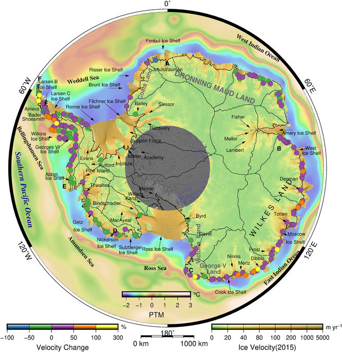
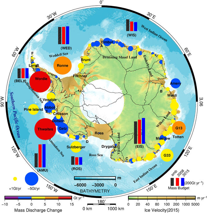
In this contribution, we constructed two Antarctic-wide high spatial resolution (100m) ice velocity maps covering the years 2014 and 2015. Tese maps provide a new tool for obtaining a more comprehensive understanding of the current ice dynamics in the area. We found a signifcantly increased mass discharge of 53±14 Gt yr-1 in the East Indian Ocean sector over the last seven years. Tis increase was attributable to widespread acceleration in the glaciers of Wilkes Land, East Antarctica. Te other fve oceanic sectors did not exhibit distinct changes in mass discharge; however, the contemporary view is that present-day increased mass loss primarily originates from West Antarctica and the AP. Over the time period of our study, the Antarctic ice sheet as a whole exhibited an increased mass loss of 81±100 Gt yr−1, which was equivalent to an increased mass loss of 54% since 2008(−149±71 Gt yr−1). More importantly, we found that Wilkes Land in the East Indian Ocean sector contributed most to increased mass loss, reaching 53±47 Gt yr−1. Te signifcant increase in mass discharge in Wilkes Land suggests the potential risk of the destabilization of the marine-based sector of the EAIS, which has large subglacial basins, inland-sloping bedrock and deep troughs, i.e., an instable bedrock confguration similar to that in West Antarctica. Our new high-resolution ice velocity maps together with historic InSAR ice velocity data allow us to determine the frst continent-wide changes in ice velocity and ice discharge over the past seven years. These results contribute to our understanding of Antarctic-wide ice dynamics and can potentially improve ice sheet modelling and future sea level projections.
Therefore, the risk of instability in Wilkes Land should deserves more attention. In the future, it should also strengthen its long-term monitoring and research. It is of special significance for the accurate prediction of sea level.
Papers and related supporting materials: (www.nature.com/articles/s41598-018-22765-0)