As an important part of terrestrial water, groundwater plays an important role in the water cycle and is also an important source of water supply in northern China. The West Liaohe River Basin, located in the eastern part of Inner Mongolia, is known as the "Inner Mongolia Grain Storehouse." Since 1980, due to climate change, agricultural development and rapid population growth, surface water cutoff in the Western Liaohe River Basin has occurred from time to time, and groundwater has continued to be mined. Research on groundwater changes in the area has important practical significance for safeguarding the sustainable development of agriculture and the formulation and implementation of related water policies. In 2002, the Gravity Recovery and Climate Experiment (GRACE) satellite launched by Europe and the US was widely used in the accurate determination of the time-varying gravity field of the Earth to quantitatively invert the surface and internal quality (including snow, water, and solid earth mass, etc.) migration processes. It was widely application in Geodesy, hydrology, oceanography, geophysics, and cryosphere science.
Recently, the “Satellite Geodesy and Global Change” research team of Institute of Geodesy and Geophysics, Chinese Academy of Sciences(IGG,CAS) has systematically analyzed the temporal and spatial variation of groundwater reserves in the West Liaohe River Basin through the joint use of GRACE satellite gravity and surface observation data. GRACE detects a GWS decline rate of −0.92 ± 0.49 km3/yr in the WLRB during 2005–2011, consistent with the estimate from in situ observations (−0.96 ± 0.19 km3/yr). This long-term GWS depletion is attributed to reduced precipitation and extensive groundwater overexploitation in the 2000s. Long-term groundwater level observations and reconstructed total water storage variations since 1980 show favorable agreement with precipitation anomalies at interannual timescales, both of which are significantly influenced by the El Niño-Southern Oscillation (ENSO). Generally, the WLRB receives more/less precipitation during the El Niño/La Niña periods. One of the strongest El Niño events on record in 1997–1998 and a subsequent strong La Niña drastically transform the climate of WLRB into a decade-long drought period, and accelerate the groundwater depletion in the WLRB after 1998. This study demonstrates the significance of integrating satellite observations, ground-based measurements, and climatological data for interpreting regional GWS changes from a long-term perspective.
The development of this research can effectively fill the data gap between the GRACE plan and related satellite projects that have not yet been launched; it explains the significance of monitoring and interpretation of long-term sequence groundwater changes in conjunction with satellite gravity and surface hydro-meteorological observations. The research team plans to further carry out similar work in major river basins in China and quantitatively analyze the changes in groundwater reserves in China for nearly 40 years, providing decision support for China's groundwater monitoring and water resources management.
Related papers were published in Remote Sensing, a major international remote sensing journal, in March 2018, entitled ”Groundwater Depletion in the West Liaohe River Basin, China and Its Implications Revealed by GRACE and In Situ Measurements”. The first author of the paper is Dr. Zhong Yulong, and the author of the communication is Feng Wei, associate researcher (list of authors: Zhong Yulong, Zhong Min, Feng Wei, Zhang Zizhan, Shen Yingchun, and Wu Dingcheng). The study was funded by the National Natural Science Foundation of China(NSFC) and the China Academy of Sciences’ Strategic Pilot Science and Technology Project.
Paper links: http://www.mdpi.com/2072-4292/10/4/493
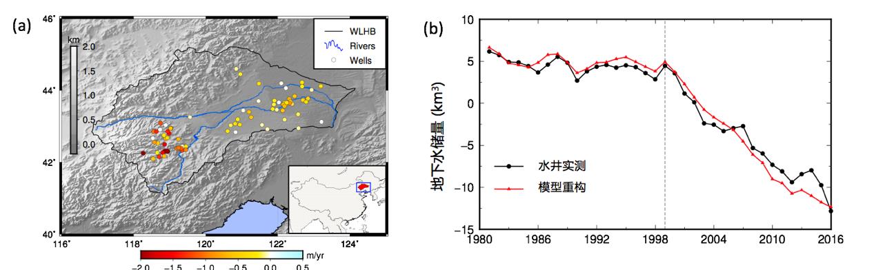
Figure 1. (a) Velocity map of groundwater levels in the West Liaohe Basin (2005-2011); (b) Time series of groundwater change in the West Liaohe Basin (1980-2015)
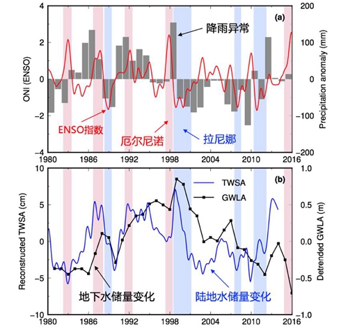
Figure 2. (a) Rainfall anomalies and ENSO indices in the West Liaohe Basin; (b) Relationship between groundwater changes, land-water changes and ENSO events in the West Liaohe River Basin